Form 8
Meet Great Britain
Aims:
- to give students basic information
about the subject they are going to learn about;
- to inform students about the
geographical position of the UK
- to enrich the outlook;
- to develop skills of listening,
reading, speaking and writing;
- to teach students to listen
carefully, to summarize, to work in groups and individually.
Equipment: the maps of the UK
The procedure:
Warming-up.
Each student gets the card with the riddle and the number (1-12). Their
task is to guess the word and to write the first letter of it on the blackboard
in the square marked by the number the student has in his/her card.
G1
|
R2
|
E3
|
A4
|
T5
|
B6
|
R7
|
I8
|
T9
|
A10
|
I11
|
N12
|
(Students guess the riddles, go to the blackboard
and write the letters as far as they know the answer. If there are
difficulties, the class helps. 4 min)
The riddles
- It
is green and everywhere on the ground seen. (Grass)
- It
is a very beautiful sweet smelling flower, a flower of love, but with thorns.
(Rose)
- This
is the biggest animal in the world that doesn’t live in water. (Elephant)
- This
fruit grows on an apple-tree. (Apple)
- A
hot drink that is made of leaves and is very popular with British and all
over the world. (Tea)
- The
animals that can fly. (Birds)
- In
- It
is cold and very tasty. It can be vanilla, chocolate and with jam. (Ice
cream)
- A
person who teaches you at school. (Teacher)
- They
also live on the earth but they are not people. (Animals)
- The
international computer net. (Internet)
- 1,2,3,4,5…
They are … (Numbers)
Now you know the topic we are going to speak about. It is Great Britain
I really have much to tell you and there will be a series of lessons
dedicated to Britain
First look at the sentence.
"Great
Britain " has several different names, some people
say "Britain ", or
"the United Kingdom ",
or just "the UK
How many names of the country are mentioned?
What do you think is the official name of the state?
What is the abbreviation?
Remember to use the article where
necessary. If the name of the state consists of several words, it is used with
the article “the”: The United
Kingdom
Now when you know the name of the state, look at the map of it. Listen
to a summary and then be ready to correct the mistakes in the sentences. (4
min)
There are four different countries in the United Kingdom : England ,
Scotland , Wales and Northern Ireland Britain ,
many of them in big industrial cities like London ,
Liverpool and Manchester Northern Ireland is situated
in the northern part of Ireland United
Kingdom London
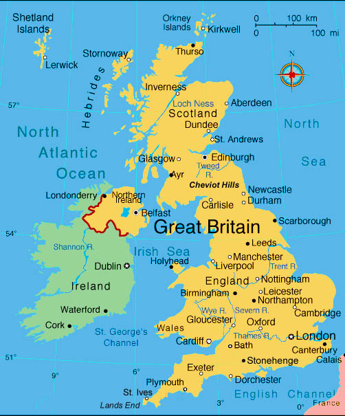
Now look at the sentences and correct them if necessary.
- There
are five different countries in the
- Altogether
more than 56 million people live in
- The
territory of the
- The
capital of the country is
OK. Let’s move on and add some facts about the geographical position of
the state. Now, can I ask you to make three groups? Each group gets:
- the geographical map of the UK
- short information about mountains,
rivers or waters that wash Great
Britain
- new words with the transcription to
help you to read new geographical names.
Please read the texts and get ready to tell the class what you have
learned. Remember that everybody has to tell us at least one sentence. While
you work I come and help with the pronunciation of the new words. So, begin,
you have some minutes. (5 min)
The task for group 1:
The English Channel - пролив
Ла-Манш
The Strait of Dover- пролив
Па-де-Кале
The Irish Sea-
Ірландське море
The North Sea- Північне
море
The North Channel- Північний
пролив
The Atlantic Ocean- Атлантичний
океан
The task for group 2:
Lowland Britain-
The North West Mountains- Північно-західні гори
The Grampians- Грампіанські гори
The Pennines-
Пенінські гори
The Cambrian Mountains- Кембрійські гори
The task for group 3:
The rivers of the region are short
and of no great importance as waterways. The longest of them are the Severn (354
km ) and the Thames ,
which is 346
kilometers long. Other comparatively long rivers are:
the Trent Tweed , and the Wye. Lakes are found in the Lake District in England Scotland Scotland
The Severn- річка
Северн
The Thames-
річка Темза
The Trent-
The Tweed- річка Туїд
The Wye-
річка Уай
The Lake District-
Озерний
Край
All right, it’s time to share information. Please, all members of the
group 1 come to the blackboard and one by one tell us what you have learnt and
show everything on the map. Then go group 2 and 3. (6 min)
(Students speak and listen to each other in
order to get first outlook)
Now please, change the cards. Group 1 gets the task of group 3, group 2
of group 1, and group 3 of group 2. You had the opportunity to hear everything
that is in the card, and now you will also read. And the task is to make up
questions on the subject. When the group asks the other two groups answer.
Don’t forget to use the maps. Let’s take turns. Group one is the first to ask.
(5 min)
Good job! And now after intensive work I am sure you need some rest. Let’s
play “Bingo!”. All the new geographical
names are written on the blackboard. Draw a model for the game. As you remember
it is a table of nine cells. Then put down some nine names in them. (5 min)
Example:
the Wye
|
||
the
|
the
|
|
the
|
the
|
Now I read you the names and if you hear one from your table, cross it.
If you have horizontal, diagonal, or vertical crossings, rise your hand and say
“Bingo!”. The first is the gold winner and the second and the third are silver
and bronze winners. (1 min)
The English Channel, the Lake District, the North West Mountains, the Atlantic Ocean, the Irish Sea, the Thames, Loch Ness, the Strait of Dover, Snowdon, British
Isles…
Now tell me, what geographical names are the most difficult for you to
read and remember? Let’s all together pronounce them again. (1 min)
(This activity helps the teacher to find out
difficulties and help)
Good. And now I have a question. Why do we use some names with the
article and the others without it? You do already know some of the rules. It
will be great to remember them and to add some new ones. (2 min)
So, we use the article ‘the’ with:
- the chains of mountains;
- the channels, rivers, seas, oceans;
We do not use the article with:
- the names of the mountains;
- the names of the lakes;
- the names of the islands.
Now I propose to play the game. I pronounce geographical names without
the article, and you repeat all together either with it or without. (2 min)
English Channel, Lake District, North West Mountains, Atlantic Ocean, Irish
Sea, Thames, Loch Ness, Strait of Dover,
Snowdon, British Isles, Great Britain, United Kingdom, Wye, English Channel…
Well, I think that you were really working hard at the lesson. We have
learned many facts about this country. And if you were attentive, it would be
easy for you to pass the test. Open your exercise-books and write down the word
‘Test’. It will be a multiple choice
test. Choose ‘a’, ‘b’, or ‘c’. (5 min)
1. The United Kingdom
a) England Scotland Wales Ireland
b) England Scotland Wales Northern Ireland
c) Britain Scotland Wales Northern Ireland
2. Great Britain
a) the English
Channel .
b) the North
Channel .
c)  the
the Irish Sea .
The model of the map
the
3. The highest peak in Great
Britain
a) Ben Nevis .
b) Snowdon .
c) Loch Ness .
4. The longest rivers in the UK
a) the Trent Tweed .
b) the Wye and the Strait
of Dover .
c) the Severn
and the Thames .
5. The British Isles are surrounded by
the shallow waters of …
a) the Irish Sea
and the North Sea , the North
Channel and the Indian Ocean .
c) the Irish Sea
and the North Sea , the North
Channel and the Atlantic Ocean .
6. The population of the United
Kingdom
a) 48 mln people.
b) 56 mln people.
c) 244 mln people.
The final part
Home assignment.
Well, that’s it for the first lesson. As a home assignment for the next
lesson I give you the models of the maps where you can see only the shape of
the country. Your task is to colour them, write all the geographical names
there and speak about the geography of the UK
The teacher analyzes the lesson and student’s work, gives marks. (3 min).
Немає коментарів:
Дописати коментар